Includes discussion of the steam vs. lava hypotheses of the mechanism which lifts these domes of largely solidified lava.
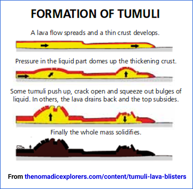
Lava blisters are a rare geological formation as a crust of a fresh
molten lava flow, which solidifies and is pushed upwards into mounds
which remain to this day.
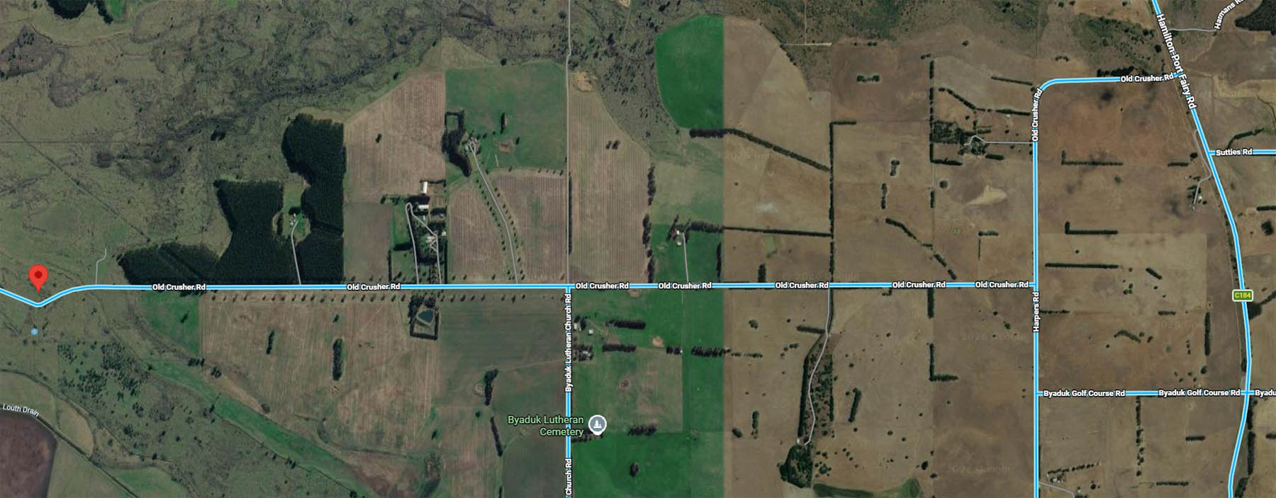
The Nomadic Explorer However, few have detailed photos. Here are ours. First, directions on how to get there:
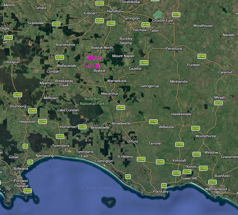
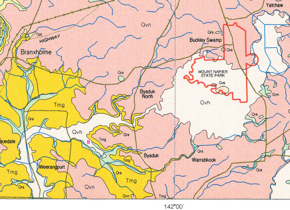
Google maps location Here is the location, within south-west Victoria, with BD indicating
the location of the volcanic Byaduk Caves, just west of the volcano
Mount Napier:
To the south is the Mt Eccles (Buj Bim National Park), with its lava cave, lava tubes, lava lake and lava channels,
where the molten rock melted its way as it flowed, through the basalt
formed by previous flows, and then drained away towards the ocean,
leaving a channel 20 to 70 metres wide, and 6 to 10 metres deep.
(Watch out for leeches!) https://www.google.com/maps/@-38.0713214,141.906557,219m/. -38.07118, 141.90661.
Mt Napier (If this was our land, we might not want
to encourage or support people walking in, due to potential legal and
insurance complications, and also to discourage those with only a
passing interest in geology.
If we wanted to keep people out, we would install a warning sign to this effect, and keep the gate locked.
We would want responsible, appreciative people to be able to experience
these geological formations, so we wouldn't lock the gate.
The implication being that anyone who entered did so at their own risk,
and should tread lightly, watch out for bulls, snakes and leeches - and
leave no rubbish behind.
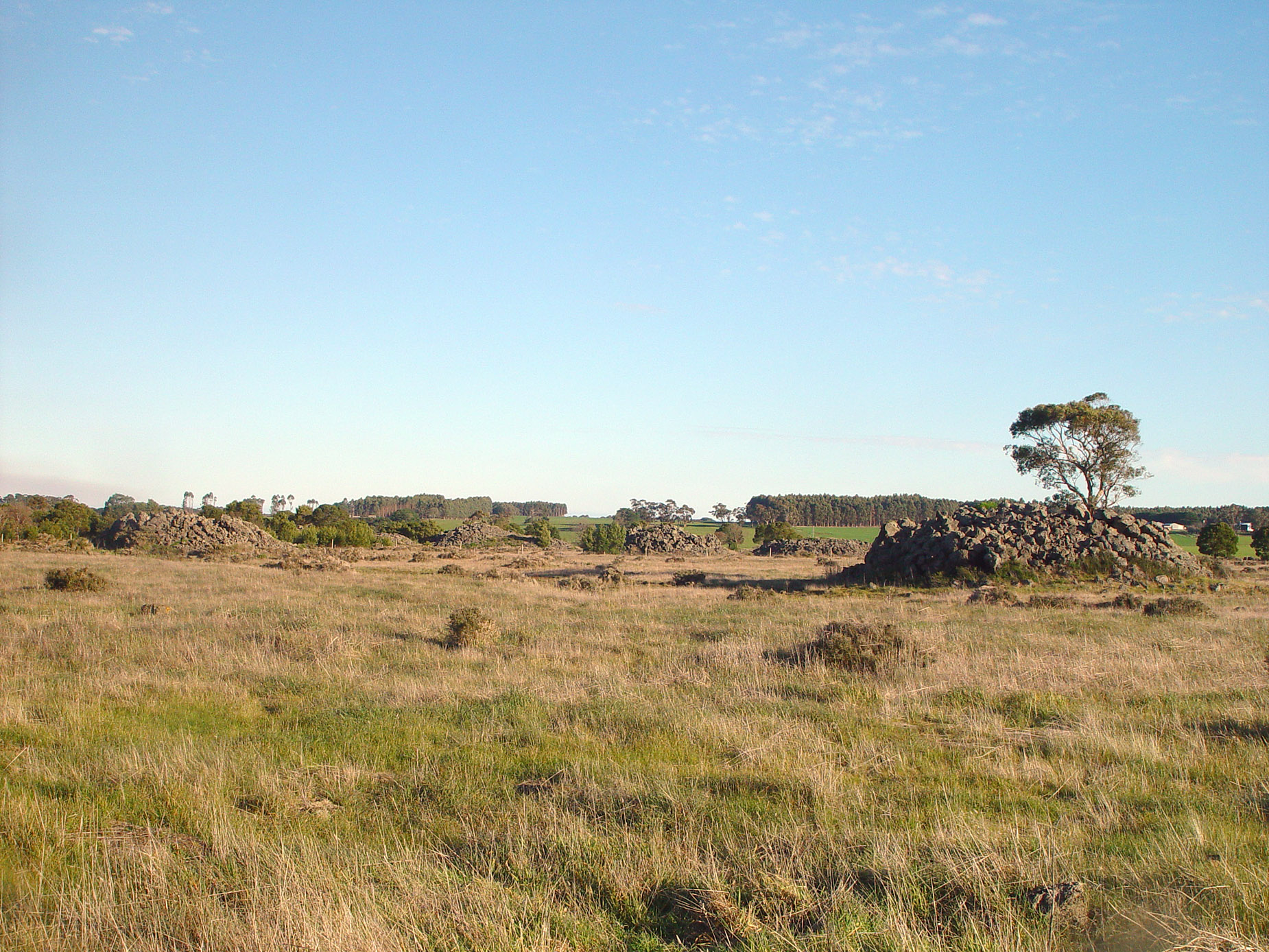
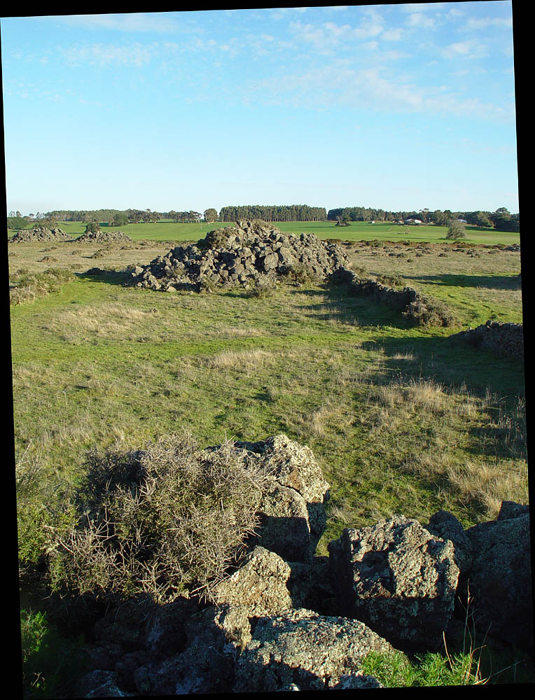
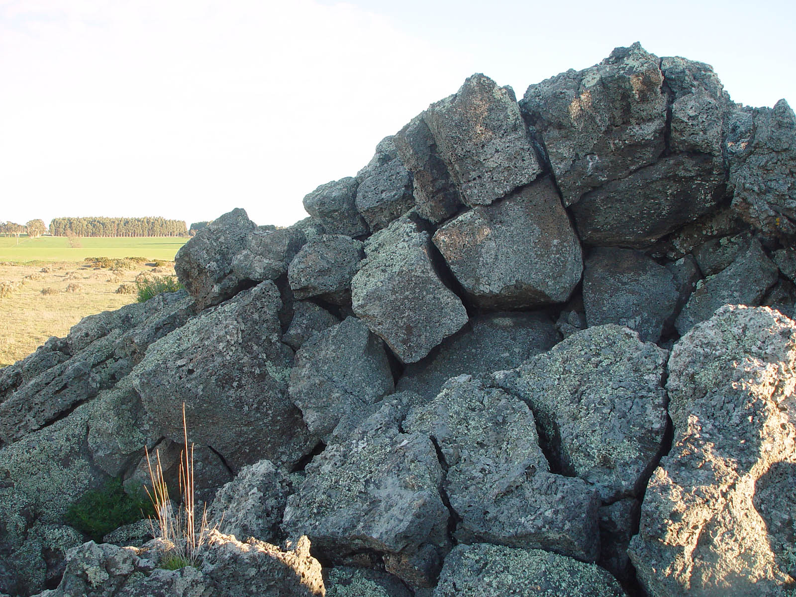
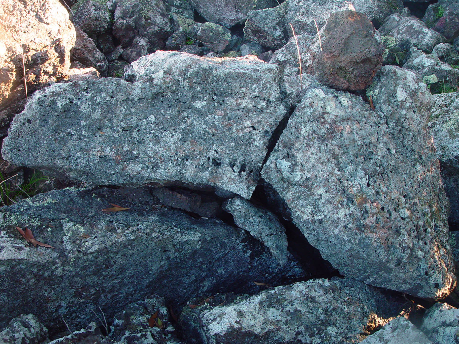
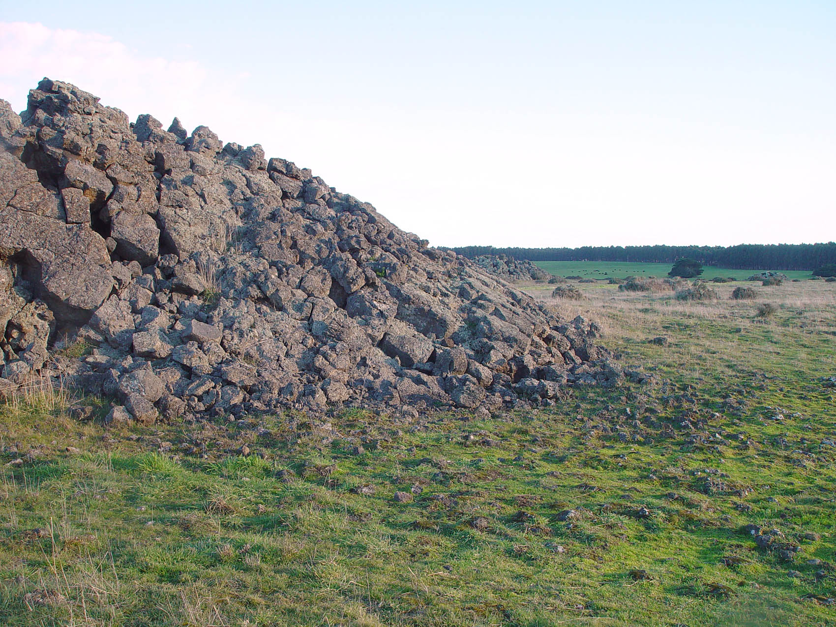
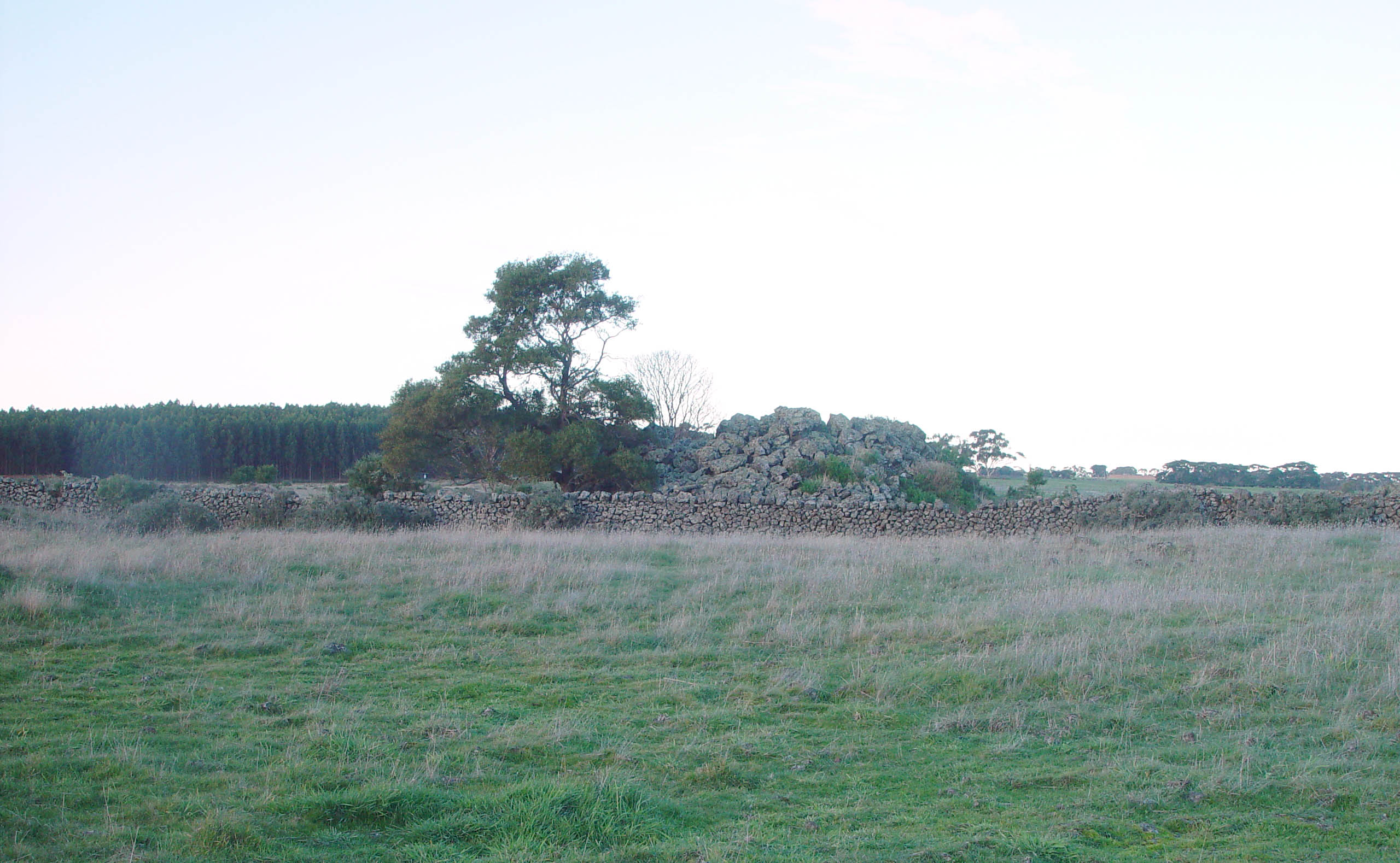
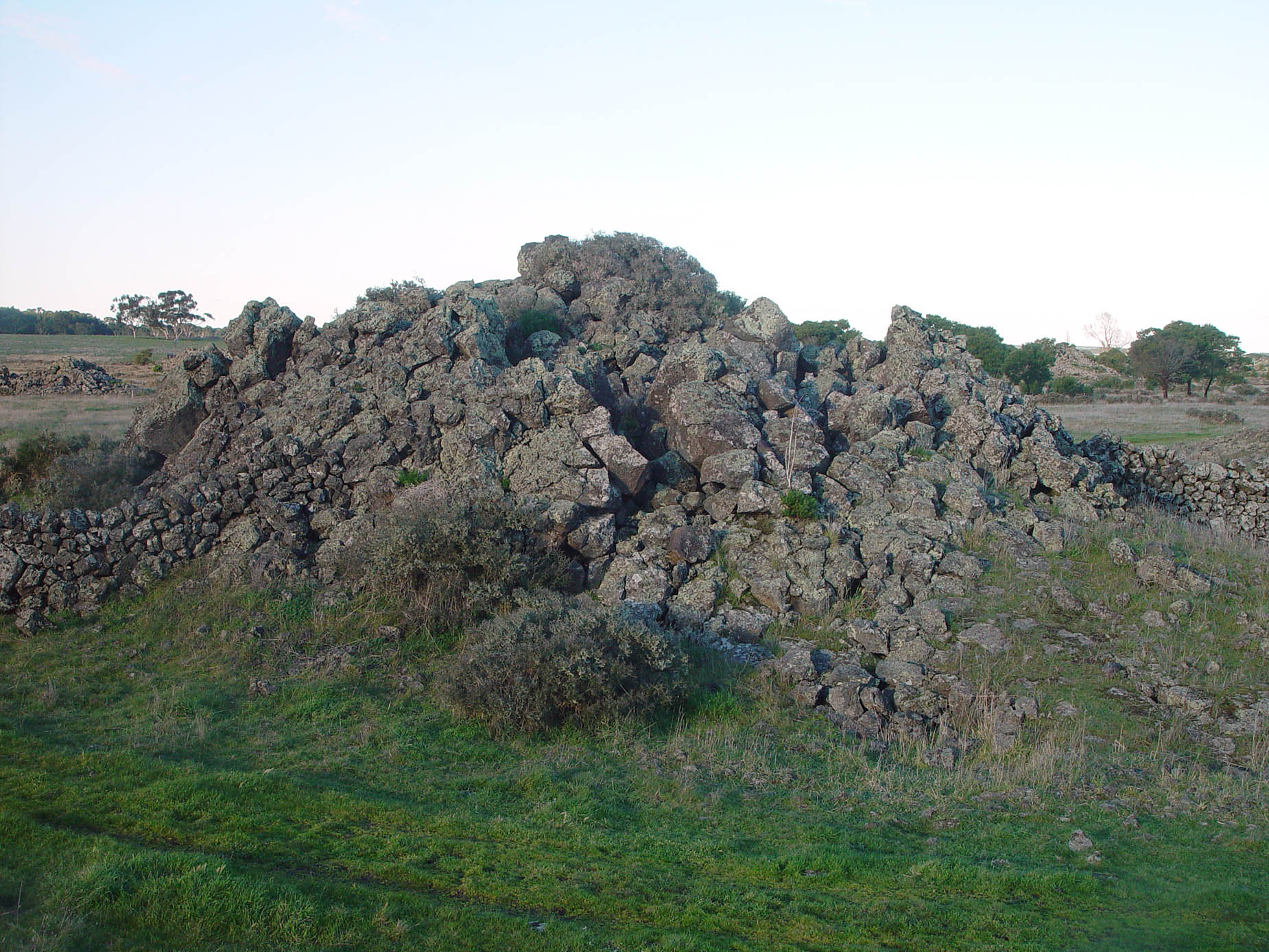
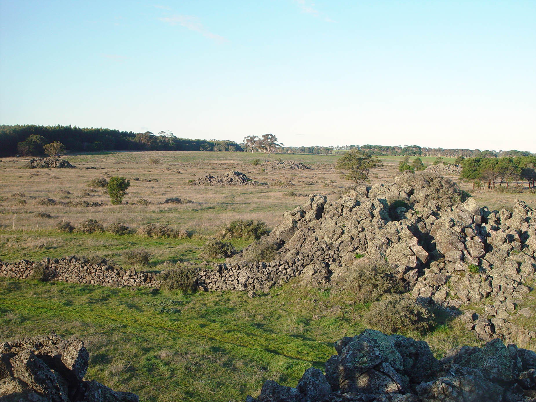
Drystone walls made by stacking basalt boulders.
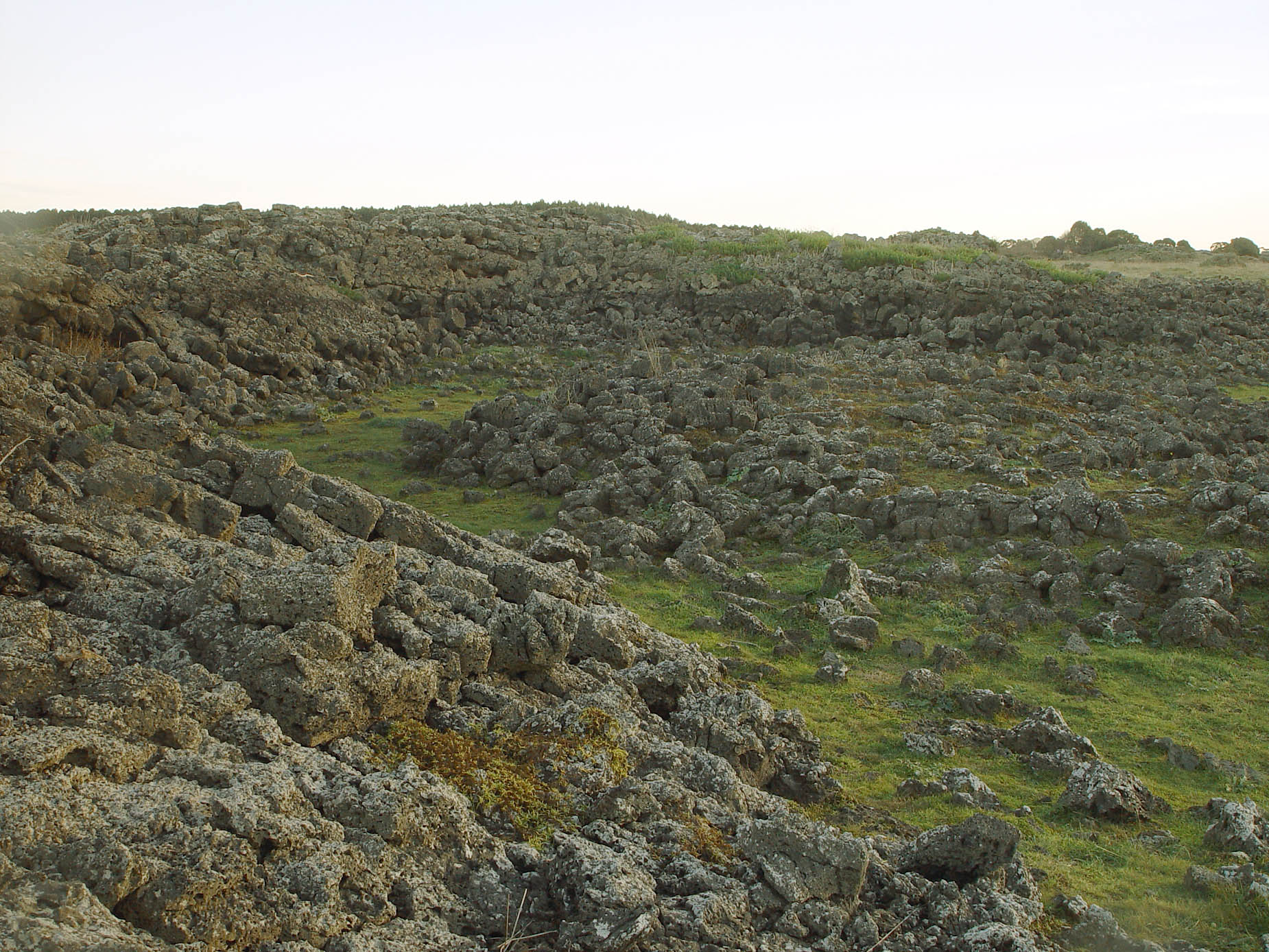
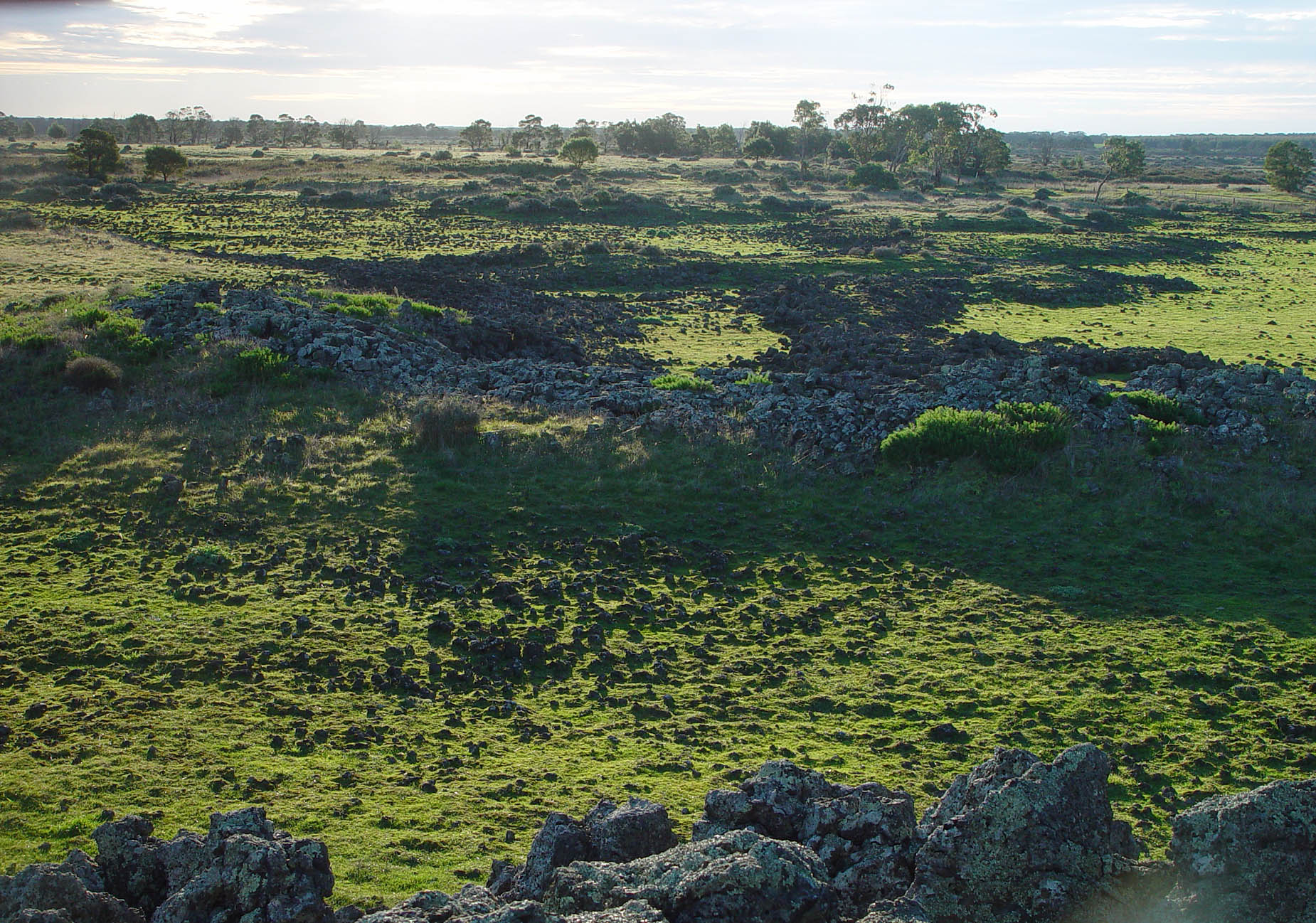
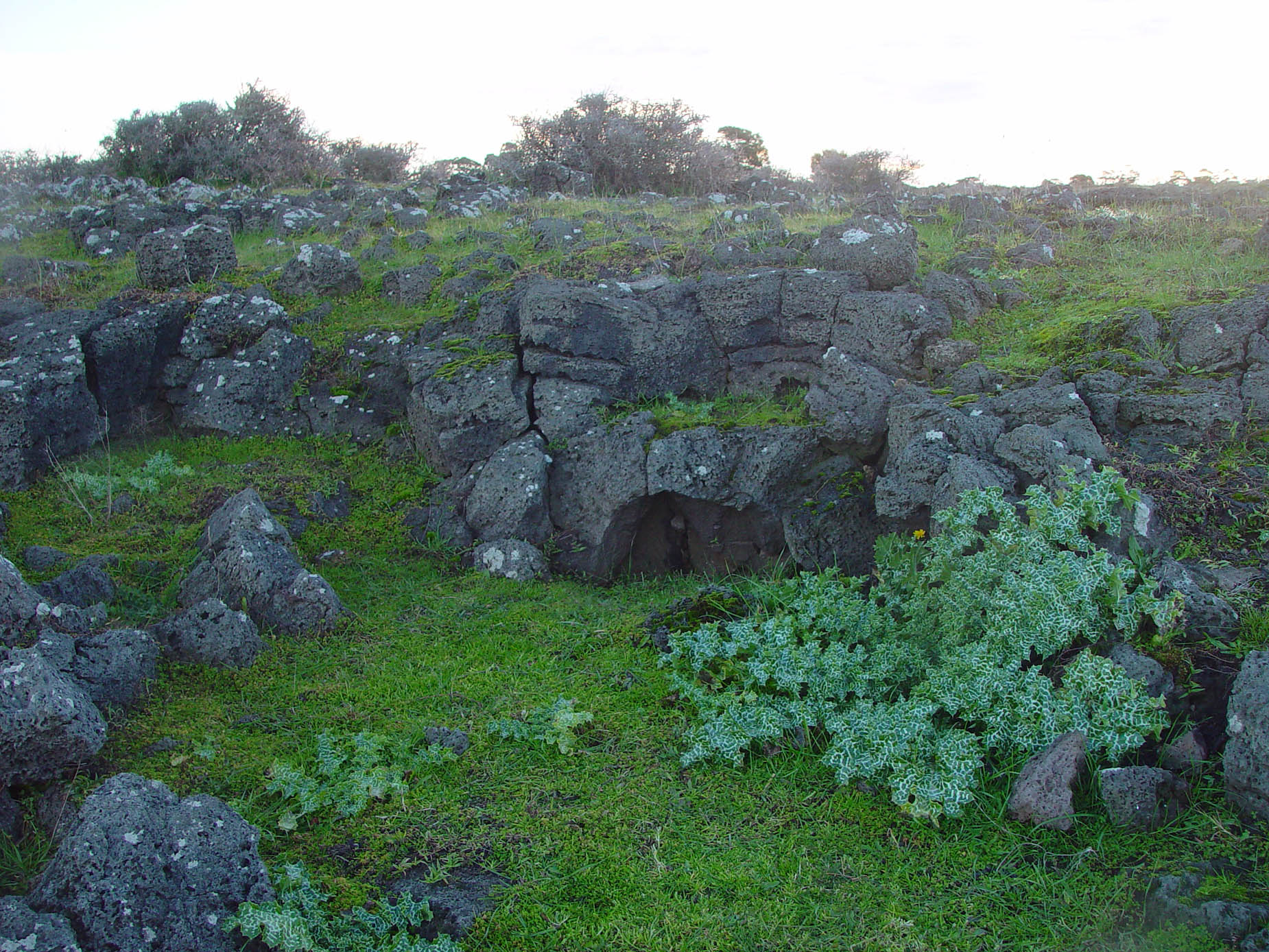
#sh
Initial notes on the steam hypothesis of lava blister formation
I wrote the following on 2026-10-25, before I properly read the except above from Ollier & Joyce (1964):
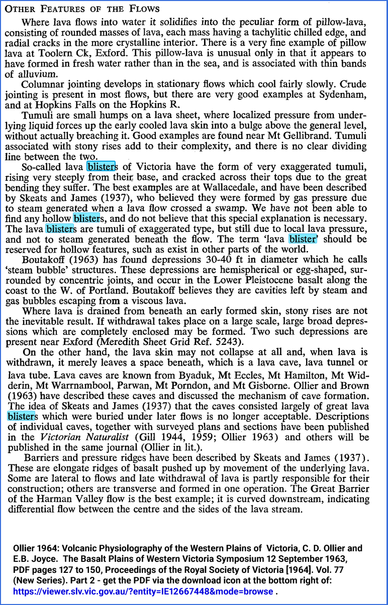
Ollier and Joyce (1964), above, states "We have not been able to find any hollow blisters".
They attribute the formation of the blisters entirely to pressure from lava.
However . . . why would heavy lava rise up like this, some
of it evidently above the elevation of the top surface in the crust
surrounding it, pushing up the stiff crust to such heights above the
top of the rest of the crust, that the elevation of the top of the
molten lava below the highest part of the now dome-like crust is, I
guess, above the top of the surrounding, level, crust?
This does not make sense from a hydrodynamic point of view, any more
than does the idea of a patch of liquid water in a top-frozen lake
rising up to push the ice above it into a dome (though the ice is more
resistant to bending and cracking than the still potentially somewhat
soft, cooler, lava of the crust).
Ollier et al. refer to the intense bending of the crust at the top of the
blister causing it to open up with cracks, which can be seen in photos
above.
While hollow arch-like formation pictured above is arguably not that of
a proper lava blister, it looks hollow, as if it was pushed up by gas -
and the rock above it looks like it has been bent upwards to some
extent.
Alternatively, it might have been pushed up by lava which subsequently drained away. But why would that happen?
The whole body of recently arrived lava is no longer moving. It
is cooling from the top with cool air and radiating its heat into
space, while it is sitting on cold rock, only metres below.
It is easy to imagine the lava heating some water in the rock below and
this rising as high-pressure steam with enough pressure to push up, and
deform, the still somewhat plastic lava, which I guess would be red-hot
inside, with the outside crust not radiating much in the visible
spectrum - until the cracks appeared.
The next day (2026-10-26) I read the excerpt, which includes:
The
so-called lava blisters of Victoria have the form of very exaggerated
tumuli, rising very steeply from their base, and cracked across their
tops due to the great bending they suffer.
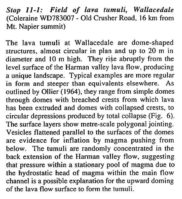
The best examples are at Wallacedale [this site, just to the east of Wallacedale] and have been described by Skeats and James (1937), who believed they were formed by gas pressure due to steam generated when a lava flow crossed a swamp.
They dismiss this steam hypothesis, but it is not clear why. They
also mention that Boutakoff (1963) had the same hypothesis for the
formation of some basalt formations along the coast to the west of
Portland.
There are quite a few things to research here. We need not assume
that every formation which is classified as a larva tumulus necessarily
forms by the same, or even vaguely similar, mechanisms.
A new friend of ours is a
PhD igneous petrologist. So who we gonna call??
He sent us Anderson et a. 2012
Tumulus development on lava flows: insights from observations of active tumuli and analysis of formation models,
sci-hub.su/10.1007/s00445-012-0576-2.
However the flows these researchers observed were in moving lava flows,
which I think were quite deep, with very thin (< 5 cm) crusts.
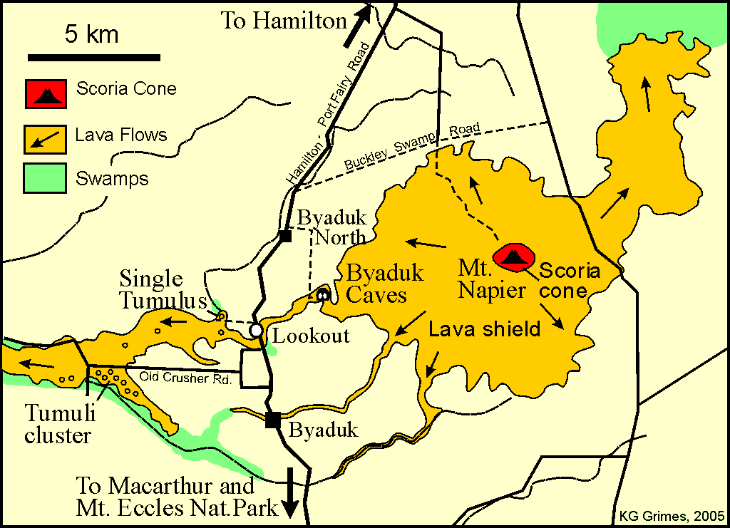
The lava blisters we observe here, between Byaduk and Wallacedale,
involve something thrusting semi-solid crusts several metres thick, to
elevations of up to 5 metres or perhaps more from where the crusts
formed, as a generally flat layer, over presumably hotter and more
fluid lava.
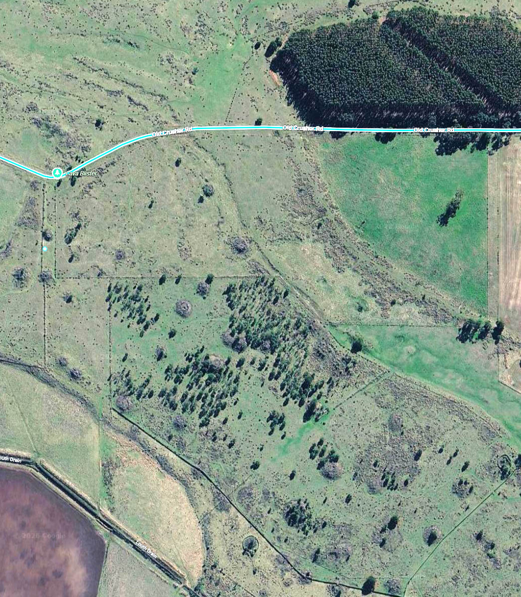
I haven't researched this field yet, but my tentative impression is
that the field of lava blisters we pictured above, south-east of the
kink in Old Crusher Rd, are the are the most striking examples of
their kind anywhere in the world.
There may well be other instances of lava blisters which formed by the
same process elsewhere - and Ollier & Joyce (1964) suggest a few
locations we can research. However, other somewhat similar
formations my have been formed by different mechanisms, or perhaps by
gas or steam which was generated in quite different circumstances to
those at work here.
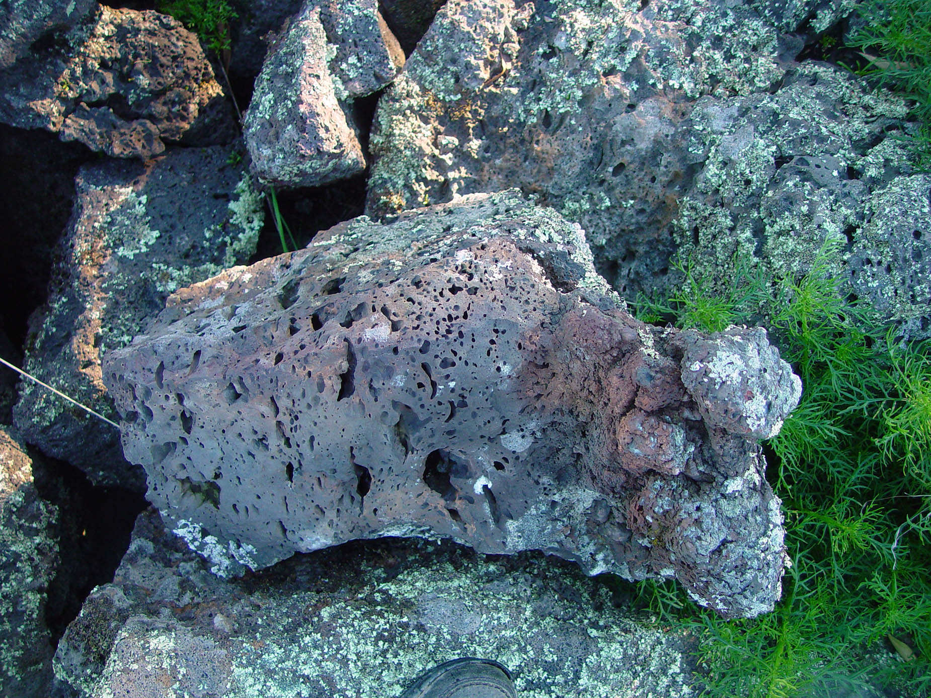
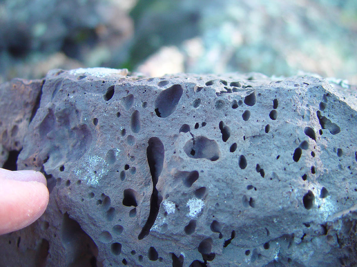
Here is a closeup of the ~~1 metre diameter, approximately dome shaped,
hollow space inside a deformed layer of crustal lava which was, and
remains, ~~ 2 metres thick.
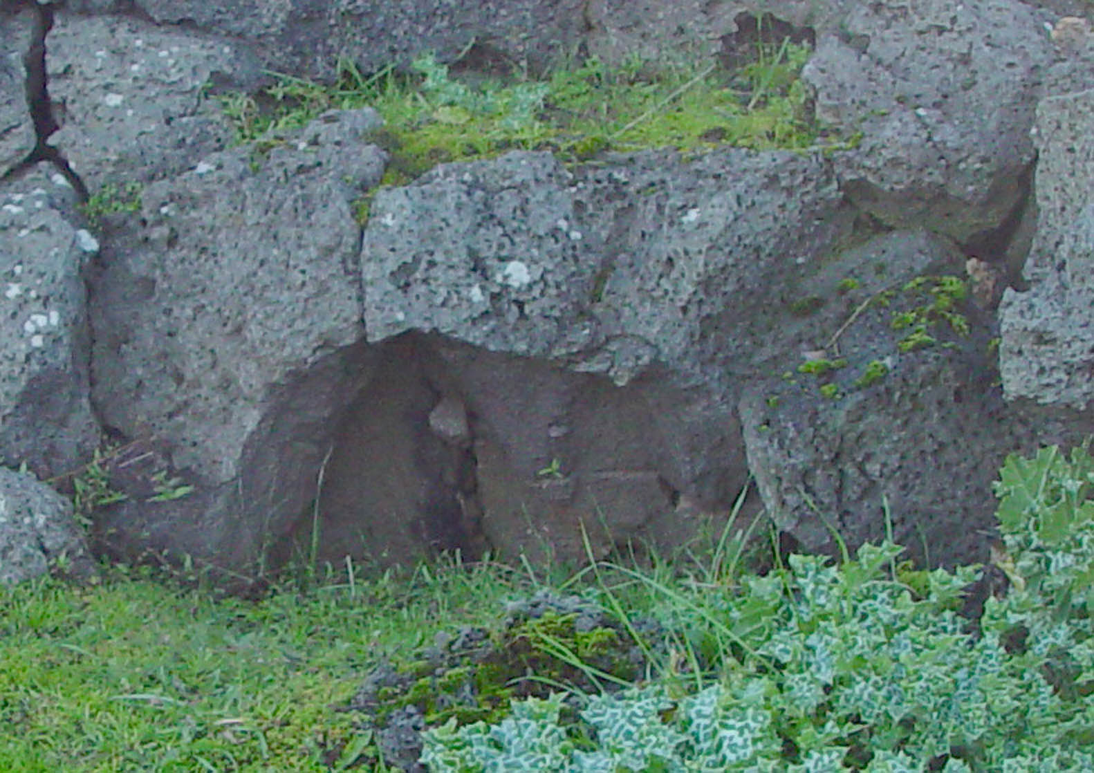
I remember taking this, the last photo of the day. I hadn't looked at the images since 2017.
This is a curious and distinctive formation. There's no
sign of dripping lava, as there might be if a cooler surface was pushed
up by hotter lava which remained hot and fluid enough to drain away
suddenly, before transferring more of its heat to the rock we see here.
Note especially the lack of outgassing bubbles on the inner surface of the dome.
This ~~1 metre
2 area dome, which I think of as the top of a bubble of steam, was pushing up much more than the ~~ 2 metre
3
of semi-stiff crustal rock directly above it. We can see the
pressure lifted, to some extent, crustal rock (since it retains its
layered structure, even when bent, which would not happen if it was
still liquid) more than half a metre from the centreline through what,
I assume, was a roughly hemispherical top of the bubble.
That requires significantly more steam pressure than would have existed
at the base of these layers, due to their weight (I am assuming ~~ 2
metres thickness), when they had been laying flat like the undisturbed
parts of the same layers nearby.
While at that ordinary pressure, the lava was outgassing and forming
small bubbles as it cooled, which remain to this day, I hypothesise
that the outgassing process was inhibited to some degree within 5 to 15
cm of the surface of the dome, or at least that the small bubbles
which had already formed there would have become smaller due to
compression and also perhaps due to the gasses going back into solution
into the lava.
Close examination will test this hypothesis, and with longer days over
the next few months, we will certainly be doing a field trip!
Here are a few questions:
1 - Clifford David Ollier (
Google Scholar and 1992 Life and Times
onlinelibrary.wiley.com/doi/abs/10.1002/esp.3290170403) and Edmund B. Joyce (Bernie Joyce
unimelb.academia.edu/BernieJoyce) presumably visited this site in the early 1960s and had a close look at all the formations.
They mention some or many of the formations collapsing, at least
partially, which would be consistent with steam being the cause of
their formation. They looked for, but did not find, hollow lava
blisters.
So was this formation pictured above visible to them at the
time? If not, then perhaps someone cut it open . . . but
that would require blasting and/or a heavy excavator.
2 - Their hypothesis of the motive force being an inflow of fresh lava
into the lower layers, pushing up the crust above only in particular
locations, doesn't seem credible to me, since the pressure would lift
the whole crust above a zone of molten lava. While the deformed
crust is 1 to perhaps 4 or 5 metres thick, it was surely not cold and
solid enough to be held down by its edges, against a head of lava
pressure several metres above its surface, as I think their hypothesis
requires. So why did they think this was a preferable hypothesis
to that of the steam dome mechanism?
Perhaps that hypothesis was proposed to explain other formations, and
was found to e wanting in those - and so was assumed to be wanting in
respect of these particular lava blisters.
3 - Why did they refer to "so called" lava blisters, with "lava blisters" in quotes?
The most pressing question now (2026-10-27) is to find out what Skeats
and James wrote in 1937. I will research Boutakoff (1963)
later. Here it is - the section on the Byaduk
Steam Blisters:
See also:
in which the final paragraph is:
The work recorded here indicates that the tumuli are more variable than has generally been thought, and that there is no
evidence for lava blisters at Byaduk. The term 'lava blister'
should be restricted to those features definitely due to steam bubbles
such as those described by Wentworth and Macdonald.
Support for and elaboration of the Skeats & James
steam hypothesis for the formation of these Byaduk - Wallacedale (Old
Crusher Road) lava blisters / tumuli
2026-10-29
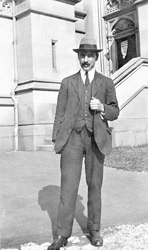
Prof. Earnest Willington Skeats (1875 to 1953) was head of the
Department of Geology, University of Melbourne, from 1904 to
1941.
adb.anu.edu.au/biography/skeats-ernest-willington-8440
Under
his leadership, the department won an international reputation as a
specialist school in igneous petrology and petrography . . .
He had a ready wit and a great
love for Gilbert and Sullivan operas, which he played and sang by heart
whenever he had occasion, particularly on student excursions.
Albert V. G. James was also at University of Melbourne. His 1920 article
Factors producing columnar structure in lavas and its occurrence near Melbourne, Australia has
91 Google citations.
Ollier (1964) denies the validity of the steam hypothesis of Skeats &
James (1937) for the Byaduk lava blisters. He further denies they
are blisters at all, since he argues that steam or water played no part
in their development, and that the force which pushed them upwards was
lava.
However, I think that Ollier (1964)'s hypothesis is not credible because there is no
hydrostatic mechanism for heavy lava pushing up so high, typically
above the surface of the surrounding crust, especially with typically several
metres of general solid crust on top of it.
Ollier (1964) cites a 1952 textbook when stating that these lava
blisters (before he disavows the use of this term for them) at
Byaduk-Wallacedale "have become the type examples". So there's
nowhere else on Earth we can go to see finer examples of these
intriguing landforms.
So far, I have only read the lava blisters section of Skeats and James
(1937) - pages 273 to 275 (PDF pages 29 to 31). There are other
items there which are potential relevant, such as Fig 16 which reveals
that a farmer to the north east of the magnificent Mt Pordon ring
barrier has a volcanic
exploded gas blister in their back paddock.
Here is the text of the lava blisters section:
(d) Steam Blisters.
At the junction of the Harman
valley and Scott’s Creek, the lava sheet is about 1 miles in width. The
surface is generally flat, but on the southern side, about fifty
isolated basalt cones project spectacularly above the plain, they are
from 20 to 30 feet in height, and about a chain in. diameter (Plate
XVIII.B, Fig. 22).
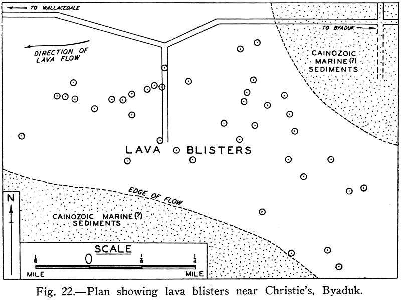
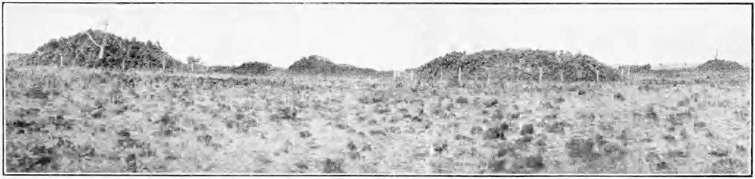
That they formed part of the original surface is shown by the
continuity of the prismatic jointing from the plain to the sides of the
cones. Columnar jointing is strikingly fresh and perfect over the
whole surface of these knolls, and scoriaceous or ropy structure is
either absent or rare. All the columns are vesicular towards the
surface. An examination of these basalt cones reveals that every one is
severely fractured. Several radial fractures from 1 to 4 feet in width
and about 6 feet in depth, are found on every knoll, and most have also
one or more concentric fractures on the upper half.
"Vesicular" means the rock contains small vesicles - bubbles formed by gas before it solidified.
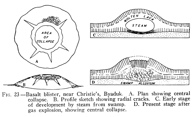
On
the crest of each cone is a basin-like depression (Fig. 23A), in the
centre of which there is sometimes a small deep hollow (Fig. 23s), and
sometimes a conical pile of columnar boulders. The interior of none of
the knolls has been fully exposed, but the gaping joints which
penetrate them give one the impression that the cones are hollow.
 From a distance these low lava
domes appear to be centres of eruption, but a closer inspection
disposes of that suggestion. It seems probable that each is a
steam blister. The lava from the Harman valley, flowing as a fairly
thin sheet into a marshy flat on which were isolated pools and
quantities of swamp vegetation, would imprison huge steam bubbles.
These probably lifted the solidifying surface, and formed cones such as
are seen there now (Fig. 23c).
That the surface was solid when the cones were formed is shown by the
concentric and radial fractures that occur on the surfaces of all the
knolls. This suggests that the steam was imprisoned in the plastic lava
beneath the contracting crust.
As the prismatic joints,. perpendicular to the cooling surfaces
penetrated deeper and deeper with continued cooling, the resistance to
the pressure of the steam within slowly decreased. Eventually the
formation of the prismatic columns weakened the crust so much that the
steam was able, by a slight explosion, to burst open the top of the
cones and escape, leading to the partial subsidence of the centre of
the arch (Fig. 23o).
"Prismatic joints" seems to be synonymous with "columnar joints" at least according to:
en.wikipedia.org/wiki/Joint_(geology)#Columnar . Perhaps "prismatic" implies some nuance - but the term is not mentioned in the main columnar joints
WP article.
~o0o~
A good hypothesis for the formation of these formations would supply
satisfying and, ideally, testable explanations for a number of questions,
including:
1 - Why are these formations so
rare? The best examples on the whole planet are right here, on or
within a few km of he Old Crusher Road site. I am yet to see a single
example of another such formation, but I have not yet searched
exhaustively. There are lots of lava flows all over the
world . . .
2 - Why are they so round, rather than obtuse, or linear?
3 - Why, at least in the formations which we recognise in this
narrow ranges of shapes and sizes, did the upwards motive force become
active when there was already 1 to 5 or so (my guess) metres of
somewhat solidified (enough to have cracked already, but not enough to
resist the force) lava had already flowed over the top and had time to
cool to a large extent?
4 - What gave rise to the force?
We can't imagine a physically
realistic mechanism for any lava being lifted to or above the top of
the solidified crust, let alone with enough force to break and lift
several metres of generally solid (or potentially well-cooled and so
very solid) rock above it.
5 - Why didn't the mechanism behind the force, if it had the potential
to act like an explosion in a full volcanic eruption, did not throw
debris far and wide? Compared to the ways of erupting volcanos,
the mechanisms at work here are contained and very much smaller.
I am tempted to think of them as rather dapper or jaunty - as befits a
certain singing professor or geology. Victoria is a good place
for such sensibilities in volcanology. Those who want hellfire,
brimstone and the real threat of being scorched and/or crushed to death
should head north to Papua New Guinea and Indonesia.
6 - Why, as described in Ollier (1964) are these lava
blisters apparently:
concentrated close to the edge of the flow, especially where lava has entered tributary valleys.
Ollier (1964) attempts to describe a later flow of lava being pressed
into and so upwards, in these edges and/or tributary valleys, but his
words - in his second last paragraph - make no concrete, physical,
sense to me.
Here's my attempt at an all-text hypothesis of formation of these lava
blisters - which I think is an apt and distinctive name for them rather
a generic shape name - "tumuli" (plural of "tumulus". That Latin
word may sound learned and profound at first, but it is a generic term
for structures in all sorts of fields, and the words
lava,
igneous and
volcanic don't even appear in its WP page:
en.wikipedia.org/wiki/Tumulus.
First we need some relatively level ground, with rock which is both
saturated with water and amenable to water flowing through it, to some
extent. So it cannot be sandy, excessively porous, or dry, except
perhaps for the first 0.5 to perhaps 1.0 metres. This is no
problem for Australian swamps, who can spend whole years slacking off,
being relatively dry on the surface.
Then we need relatively low viscosity (not lumpy or stiff) lava freely
flowing into an area where it will sit without any further movement
during whatever period of time the upwards force mechanism raises a small part of the crustal
layers to form a lava blister. We see no sign, at least here, of formations being
anything but round, as might occur if the deformed rock and the upward
force site were moving with respect to each other.
The first flow of lava into the shallow valley pushes away and/or
vapourises all water on and within a few tens of cm of the
surface. There is no opportunity for pressure to build up, since
the steam has a direct path to the atmosphere.
As the edge of the flow gets further and further from any given
location, the opportunities for steam generated at that location to escape rapidly diminish.
The initially molten rock cools to soften and perhaps harden on contact
with top surface of the earth and can be assumed to form an impervious
barrier to steam escaping.
This hypothesis relies on large amounts of heat penetrating downwards,
by the conductivity of the underlying rock, which is initially soaked in liquid
water.
Multiple consecutive flows of lava may deposit new crustal layers if it
flows over the top of the previous one or more now cooling layers which
were deposited by previous flows, presumably one on top of the previous
one. However perhaps the new flow comes under the crustal layer
lifting the entire layer up. I doubt if this occurred at or near
the Old Crusher Road site, because without the lava blisters, the
resulting lava plain is both flat and level. Neither would be the
case if a crustal layer was lifted up by fresh lava underneath it, since
such a flow would not be capable of lifting, and evenly flowing under
and outwards from, the entire crustal semisolid layer which had filled
the valley to some particular extent at the end of the previous flow.
We need the lava to be deposited and cool to some extent before the
driving force acts upon it. If some fresh lava flowed over the
site once the blisters had formed, we would see their bases being
partly buried. As far as I know, this is not observed.
Before the force becomes active, the upper parts of the lava need to cool enough to start cracking, as it contracts, so we
have both the distinctive layers and the cracks, which open up and
likely become more numerous as the top surface is bend and stretched.
If the top layer was thick and hard enough, it would be strong enough
to resist local deformation, so the pressure would either lift the
entire slab of crustal rock or be overcome by its strength, and so have
little or no impact on the final shape of that top layer.
If the stiff or at least semi-solid, and so cracking or crackable, layer
of crustal rock was too thin, then it would crack and the softer rock
below it would tend to flow out of the way, rather then behave like a
somewhat dried out piece of plasticine or Play-Doh, which causes it to
split and bend to a certain extent, as we see now, without either shattering or
flowing away.
Se we need, I guess, days or weeks to pass while the formerly molten
lava becomes solid enough to a depth of 1 to 5 metres (I guess) so that
it is a reasonably cohesive layer, or set of layers -- as I think we
see in these formations - which is ready to be pushed up and bent with
cracking, rather than behaving like a concrete slab, or something which
breaks cleanly into several large pieces.
I propose that the delay - days to weeks - before the steam develops
enough volume (the volume it would have at its current hot-rock temperature if the
pressure was 1 atm) to deform 1 to 5 metre layers of semi-solid rock,
is due to the time it takes for heat to conduct from the newly arrived,
initially very high temperature liquid lava, rock, which I guess is
largely red hot by the time the steam gathers its strength.
There will be some limit to how close to the edge of the flow the full
blister making process can work. Since such locations are close to the edge of the flow
which stops the steam escaping. So the steam can easily escape via this short path to the atmosphere by flowing through
cracks in the original rock, especially if some gravel, solid or
organic debris remains just below the bottom surface of the new
flow.
I can see well-formed blisters 30 metres from the edge of the flow, as best I can tell, for instance at:
www.google.com/maps/@-37.9402,141.8815,96m/. My hypothesis is that that we would not find lava blisters really close to the edge, such as 5 or 10 metres away.
As the heat travels downwards into the pre-existing rock, much of it is
absorbed by liquid water, taking
it up to 100C (to start with, the pressure will rise and so will the
boiling point) and then pushing it through the boiling point to become
vapour, which is highly mobile due to the pressure and its low density
which means that gravity has very little effect on it.
The rest can easily be imagined, especially once we look at the final
photo I took in 2017, which shows, as far as i can tell, a process
identical to that which I propose drives the elevation of full lava blisters,
but which in this case did not develop fully before one of two things
happened, though I suppose they might happen at the same time.
1 - All the rock cools enough that the
supply of steam - which may also be coming to a halt anyway through lack of water - can no longer
bend the crustal rock enough to move it upwards. And/or:
2 - One or more cracks appear above the top, or around the sides of,
the large bubble of steam - ca. 1 metre in diameter if I remember the
scale of what I photographed - and the current steam, and that which
follows from below, is released to the atmosphere. This reduces the
pressure to the point where either the rock stops being deformed, and
retains most or all of its just deformed shape, or falls back into the
space the steam has just pushed it above.
The 5th paragraph of Ollier (1964) describes some details of the now
solidified lava closer to the middle of the blisters/tumuli, which I
don't understand enough to be able to comment upon. I am
not sure that the statement:
The very vesicular nature of the lava suggests the rapid escape of a lot of volatiles . . .
is true. As best i understand it, a bubble in some rock - especially if it is a
smaller bubble, which means it has not moved more than a few mm from where
it formed - forms from gasses coming out of solution in a very small
amount of lava, which immediately surrounds that bubble, more than other
parts of the rock surround other bubbles.
This is not my field, but i can't imagine molten lava below the cooling
crust emitting much more gasses than the rock above does. If the molten lava
arrived earlier, it would have had plenty of time to cool and out-gas
already, as the more recent flows above it
.
. . but the escape of volatiles when the lava crust breaks is
quite a different thing from a large steam bubble pushing the crust
apart.
can be regarded as reliably established by this article, since the article does
not give sufficient details of how a steam rising in a bubble, as can
easily be imagined from the last photo above, breaking through its
semi-soft, bending and ultimately cracking, lava-rock layer would
result in a different outcome, 32 k years later, than the escape of
volatiles directly arising from liquid lava.
Perhaps Ollier, in this 1964 article, is thinking of the water vapour
somehow being wet, or cooler than the rock it is pressing
against. It won't be - it will be at exactly the same temperature
as the rock, and is nowhere near condensing into water. It would
char and perhaps ignite wood just as well as the hot rock itself or any
gasses emanating from that rock.
Using approximate figures, 10 metres of water on top of a pressure
gauge imposes an additional pressure of 1 atmosphere in addition to
whatever pressure is at the top surface of the water. The same is
true of a layer of basalt about 3.3 metres thick, though I guess it
could be more like 4 or more if the rock has a lot of vesicles.
It is easy for me to imagine steam making the apparent bubble shown in
the last photo above and deforming a larger area of semi-soft rock
above it. Locomotive boilers routinely run at 10
atmospheres or so - and such a pressure on a bubble with a 1 square
metre area, when looked at from above, could hold the weight of about 3
square metres of 3.3 metre thick rock.
Perhaps there is something unusual, in the whole scheme of things
worldwide, about the rock here, or in this part of the Newer Volcanics
Province, which enables it to hold in the pressure of a substantial
steam bubble
while it is
being deformed to a surprisingly large degree by the steam, since this
involves it stretching, at least in its lower surface where the steam
is pressing against it. Its upper sections are stretched more,
and this causes cracks. It is easy to imagine one such crack,
even if it is tiny, propagating downwards towards the bubble, whereupon
it lets the pressure out within seconds or minutes and no further
movement occurs.
I have a gut feel about the general rheology of fully molten rock as
it cools and become more solid, but it is informed only by watching
videos of volcanic processes.
Surely, fully trained igneous petrologists have fun in their prac
sessions, with giant gas fired furnaces with massive refractory brick
enclosures, melting whole cubic metres of rocks of various kinds for
the highly instructive purpose of seeing how they behave, at scale,
under pressure, in various scenarios approaching the conditions deep
underground and as the rock emerges towards the surface.
Other items of interest regarding the Byaduk lava blisters
I wonder what the
views of local - Victorian and more broadly, Australian -
volcanologists and igneous petrologists are about how these lava
blisters form.
Perhaps they don't think about them much. They are not very
prevalent and no other country, or even state, seems to have formations
which were inflated in the same way.
No-one's lives or livelihoods depend on getting the right answer to
this question of how the Byaduk lava blisters formed. But still,
the formations are there, and we want to know why. People
have probably been wondering about these things for the last 32,000
years. Perhaps someone did see them forming - but I can't imagine
such observations would survive in oral history. Also, we
want to know why such do not seem to be anywhere else.
I have not done a proper literature search. However, I did find a
2026 article - so written by currently active researchers - which
touches upon these lava blisters. One of the authors is Julie
Boyce, who compiles the official list (my term, since there is no other
list AFAIK) of Newer Volcanics Province eruption points. This is
an Excel spreadsheet, with an accompanying
Victorian Volcanoes.kmz file which shows them all in Google Earth.
Complex
eruption processes and deposits of basaltic fissures: insights from the
~37 ka Budj Bim volcanic complex, Southeastern Australia
Janine L.
Kavanagh,
Katy J. Chamberlain, Jade A. Hrintchuk1,
Elisabetta Mariani, Julie Boyce, Stefano Urbani,
Tegan A. Havard, Kate M. Williams and
Ray A. F. Cas
Bulletin of Volcanology
2026-03-31
link.springer.com/article/10.1007/s00445-026-01967-9
The observation of tumuli in the lava field at Lake Condah and Lake Gorrie is consistent with the palaeosurface of the BBVC [Budj Bim Volcanic Complex AKA Mt Eccles] eruptions being wet ground.
Tumuli have also been reported in the Lake Condah and Lake Gorrie swamplands further afield (Trowbridge 2003).
This reference is to a 185 page 2003 masters thesis which was scanned
in 2002 and is now available via the library system, but not to the
general public AFAIK, though perhaps if I drove to Monash with a USB
memory stick I could get a copy:
Palaeovolcanological
processes of the Mt. Eccles Volcanic Complex: a fissure vent system in
the Newer Volcanics Province, Victoria, Australia Rebecca S. Trowbridge,
bridges.monash.edu/articles/thesis/19574689.
They are very similar to those associated with the nearby lavas from Mt Napier (Ollier 1964b).
So these currently active researchers refer, without any mention of
doubt or controversy, that the tumuli in these two lakes, which
implicitly were raised by steam (the references to wet, swampy,
locations) are very similar to those in Byaduk, but only cite the
article which insists these tumuli were raised by uprising liquid magma.
Kavanagh et al. 2026 don't refer to Skeats & James 1937.
Perhaps this is because it is nigh-on impossible to find the article on
the Web. Google Scholar has no link for a PDF. The
State library does not enable us to find things buried in these big
PDFs which contain dozens of articles.
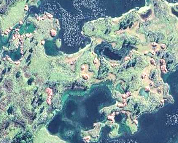
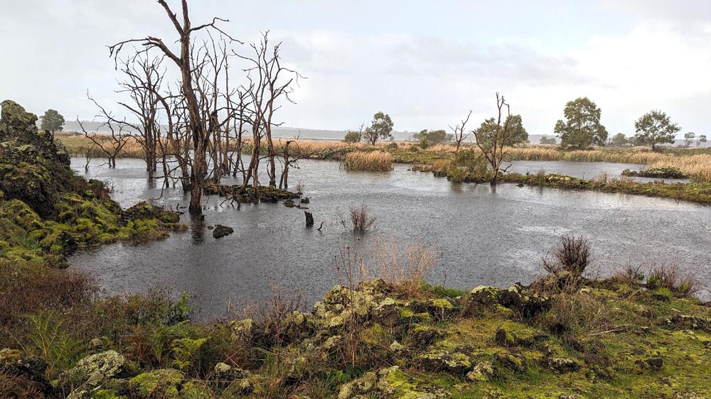
Here are the volcanic features which I assume are being referred to at Lake Condah:
These look very different to me - almost none of them are round, while
all those at Byaduk are round. I couldn't find any proper photos
of them, but here is one which show what I think is part of one of
them, and the much more complex surrounding area compared to the simple
flat lava plain of the Byaduk area. The photo are from the
Kooyang Yana Full Day Tour - Budj Bim
tour site.
I can't see an lava blister like formations on Google Maps at tiny Lake Gorrie, 6 km SW of Mount Eccles:
www.google.com/maps/place/Lake+Gorrie/@-38.1092506,141.9608804,568m/.
Second update 2026-10-29: Ollier (1964) cites page 52 of a 1953 article by C. K.
Wentworth and G. A. Macdonald:
Structures and forms of basaltic rocks in Hawaii
Chester Keeler
Wentworth and Gordon Andrew Macdonald
United States Geological Survey Bulletin 994
1953
pubs.usgs.gov/publication/b994
This section begins by referring to Pāhoehoe lava [
WikiPedia].
Here is a brilliant two minute video tutorial on Pāhoehoe and
ʻAʻā lava, with sizzling and clinking sounds, respectively:
www.youtube.com/watch?v=Lx1uDtUVf60.
My bold and colour for emphasis:
The surfaces of pahoehoe flows commonly exhibit small blisters formed by gas bubbles puffing up the still viscous flow crust. Ballooning crusts
frequently have been observed on pahoehoe rivers near the vents, where
the lava is losing large volumes of gas. The gas-inflated toes in the
gas-rich shelly pahoehoe of the early stages of Mauna Loa eruptions
have been described at the end of the section on general features.
Blisters are present on all types of pahoehoe, but are most conspicuous
on the type with a relatively smooth tachylite crust. They range in
diameter from less than an inch to about 3 feet, and in height to about
2 feet. The shell ranges in thickness from about 1 millimeter to 2 centimeters. Blisters up to 10 feet in diameter have been observed forming and bursting with minor explosions on aa flows at Paricutin (Billiard, 1947, p. 438).
It seems that Clifford Ollier agrees with this 1953 critique of Skeats'
& James' steam hypothesis of the formation of the the Byaduk
formations. The word
blister is avoided, and
tumulus is used instead.
Domical eminences as much as 30 feet high and 60 feet across on a pahoehoe flow at Byaduk, Western Victoria, have been interpreted by Skeats and James (1937, p. 273-275) as huge blisters formed by steam generated where the lava overflowed marshy ground. Nothing approaching this size has been observed in Hawaii. The hollowness of the mounds at Byaduk has not been demonstrated, and from the descriptions, it appears not impossible that these structures are actually nearly circular tumuli.
I think the last photo I took in 2017, above, is a
good demonstration
of an inflating and lifting process, with a hollow, central,
bubble-like cavity, which is apparently a stalled process which, if it
had continued, would have lead to a fully-fledged formation like the
others.
There's no reason to believe that the lava spontaneously out-gassed
enough volcanic volatiles to fill such a volume with the 1 or more
atmospheres of over-pressure required to deform the metres of somewhat
plastic lava-rock above it. That leaves steam as the only
candidate for the gas and motive force, with this presumably developing
some days or perhaps weeks after the lava first flowed over this
location.
I can't imagine any other explanation. Still, the challenge is to
understand how the bubbles grew to these immense sizes, displacing
hundreds of tonnes of somewhat flexible, but subject to cracking,
cooling crustal lava,
without a single steam leak, which would have ended the expansion in a few seconds.
This lava was initially hot and fluid enough to fill 3 km of valley,
apparently in a very level manner - yet, once cooled to a semi-solid
state, it apparently developed an impressive ability to contain steam bubbles which probably grew to 3 or 4 metres in
diameter, for the main, still elevated, blisters, and to still bigger
sizes for the larger, now fully collapsed in the middle, formations
which also occur here.
At first I thought of chewing gum, but this process is not blowing a
thin-walled bubble. The lowest part of the deformed,
semi-flexible, rock/lava which is being blown into the shape of the top
hemisphere of the bubble is indeed stretching in X and Y dimensions,
under great pressure from the metres of rock above. This entire
system needs to be substantially impervious to high-pressure steam at
the same temperature, but it is not functioning like the thin skin of a
soap bubble or latex balloon.
Rather, its apparent (or at least required for the steam hypothesis to
survive scrutiny) ability to contain the steam under these demanding
conditions could be attained by the bulk X and Y strength of the lower
part of the rock above it being stretched, while also being of a gooey
(pāhoehoe) like consistency rather than, as best I understand it, a
brittle (ʻaʻā ) consistency, in which cracks would develop easily and
propagate rapidly.
The process of steam containment would be greatly facilitated if, when
a small crack at the steam-rock interface admitted some steam upwards
and outwards towards open air, if the initial flow somehow took along
with it a little lava, such as little grains, drops or lumps, which
somehow tended to block the path the crack leads into, probably quite
close to the bottom of the crack, which is presumably where the
temperature is highest and the stretching, while still very
substantial, is less than further up or out from the bubble surface.
This would be a very particular set of characteristics of the lava,
which days or weeks ago was fluid enough to fill a valley much as water
would.
Could the steam itself alter the properties of the rock?
What if the steam contained volatile breakdown products of organic
matter and/or the underlying rock which would tend to caulk the cracks.
This brainstorming leads to the concept of a very particular set of
characteristics of the lava itself combined with another set of
characteristics of the underling rock and organic matter it contains,
or which remained, including in a roasted or burnt form, under the
recently arrived layer of now cooling lava.
Hundreds of igneous petrologists have surely lain awake at night
pondering this conundrum, trying to imagine a hollow bubble at the
centre of the process.
Perhaps part of the reason they have difficulty accepting steam as the
motive force on such a large scale is that it is hard to imagine the
bent, stretched and cracking layer of semi-flexible, rock above
containing steam or any other gas on this large scale. It is easy
to imagine it containing liquid lava, since that escaping lava, which
may owe its low viscosity to a likely higher temperature, would
probably cool and otherwise block its own escape cracks, and its
velocity of escape would be orders of magnitude slower than steam or
any other gas.
~o0o~
So far, I have found no record of researchers discovering evidence of
hollowness in the Byaduk lava blisters. Ollier (1964) states that
sterling efforts have been made to detect same:
Even experienced and diminutive spelæologists have been unable to find more than enlarged joints.
The inner lava is usually
distinct from the crust: crust lava has layering parallel to the
surface, formed by partings and flattened vesicles; the inner lava is
usually much more frothy, and even when it is rather solid, there is a
formation of 'cauliflower heads' of frothy lava immediately beneath the
crust lava.
The very vesicular nature of
the lava suggests the rapid escape of a lot of volatiles, but the
escape of volatiles when the lava crust breaks is quite a different
thing from a large steam bubble pushing the crust apart.
The fact that the resulting rock formations are often found in a
partially or completely collapsed state is a strong argument for steam
(or at least some other gas) being the cause of the inflation. It
is hard to imagine such volumes of lava suddenly draining away - in
part because there is no physically realistic way we can correctly
imagine it being pushed so forcibly above the level of the plain, as
the lava hypothesis requires.
Wentworth and Macdonald (1953) discuss tumuli on page 45 onwards.
The Hawaiian formations they are referring to do not match the height, size
or consistently circular shape of the Byaduk lava blisters:
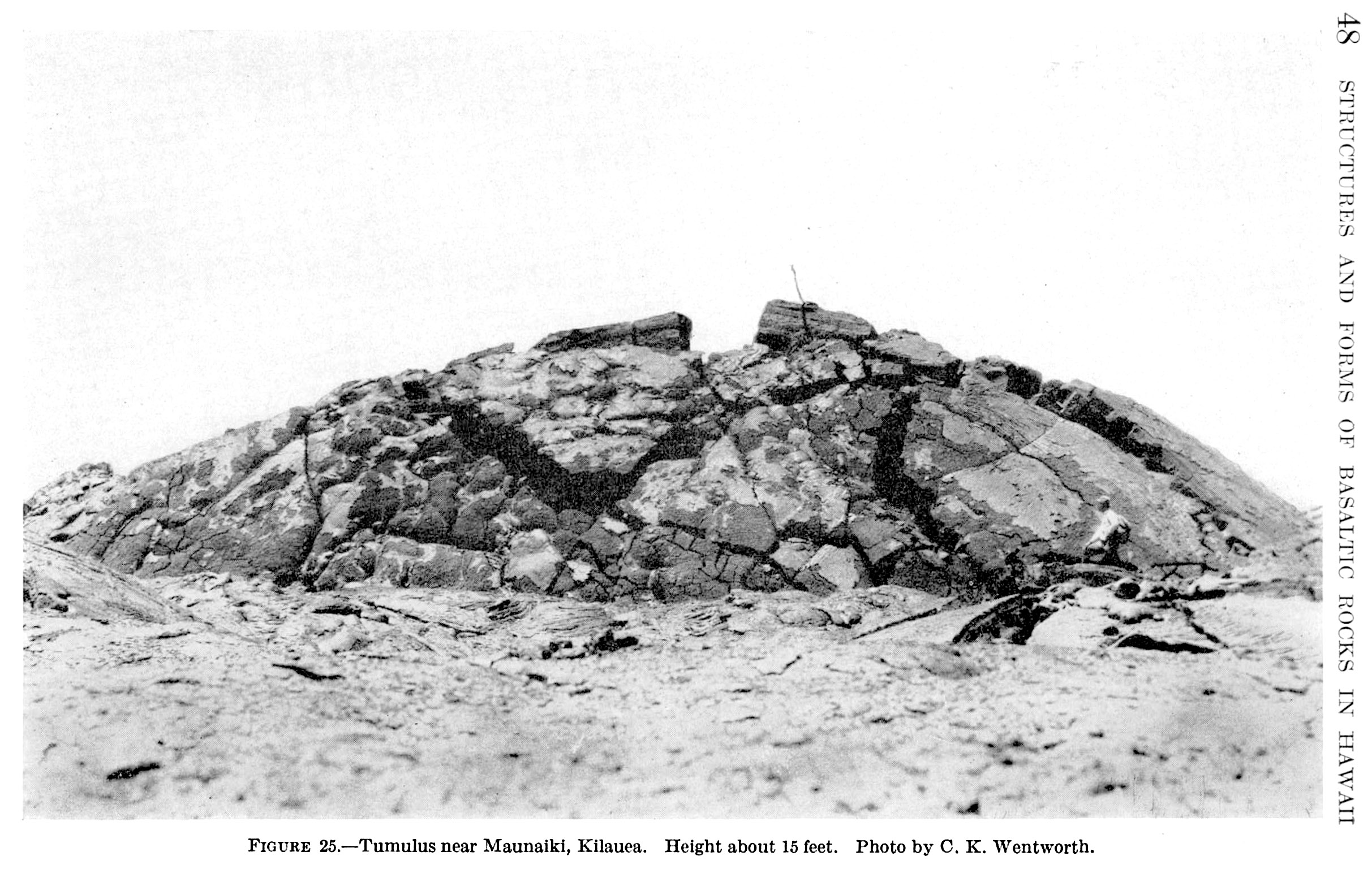
Tumuli
in Hawaii range from 1 or 2 to 10 or 15 feet in height, 10 to 30 feet
in width, and in length up to three or four times their width.
Extremely large examples, such as those of the Stony Rises near Lake
Corangamite in Western Victoria (Skeats and James, 1937) are not found
in Hawaii. Tumuli are generally cracked open along the summit, the
crack paralleling the long axis of the dome. In some instances the
crack extends to a depth of several feet, and it is possible to climb
down into it to examine the structure of the flow.
. . .
Dana (1887, p. 356) and others have explained tumuli as great blisters
raised by the pressure of gas in the flow. Careful examination of many
tumuli in the field indicates, however, that they are not formed in
that way. Tumuli are usually not hollow, like blisters, although in
some an open space is left when lava drains out.
However, the cited article by Dana
ajsonline.org/article/64732.pdf
has a different range of page numbers and does not mention blisters or
gas. Here is one of the illustrations - note the person at
the lower right.
There is an experimental line of inquiry. Melt a few tonnes of Mt Napier lava, contain it in some way as it cools
and see if we can blow a substantial bubble with it using a construction site air
compressor or, better still, a boiler.
Will lava, remelted after 32k years of being solid and exposed to
oxygen and water, behave like the original melt in the hours and days
after it emerged from Mt Napier?
Would we also have to cook up some swamp solids and other muck at 500C or whatever and mix that into the steam as well?
These very particular requirements for the steam hypothesis are a
challenge to convincing anyone of its veracity, but perhaps, due to the
impressive reality of these lava blisters - now, I think, revealed to have
a hollow bubble during their formation - and in the absence of any
fundamentally different alternative explanations, we might be tempted
to accept that the special conditions existed here. This would go a
long way to explaining why lava blisters such as these are not found
anywhere else.
To be continued.